Wall Charts
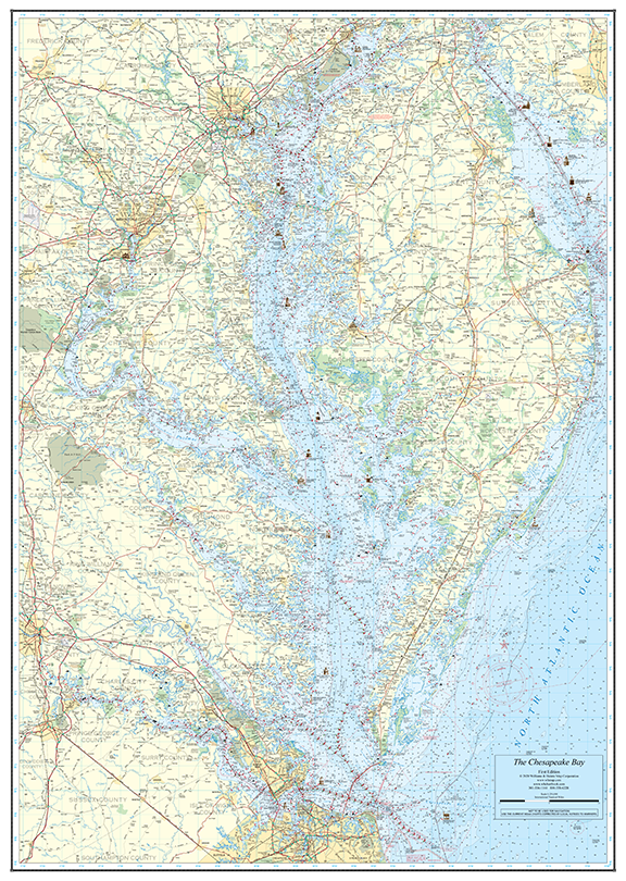
Chesapeake and Delaware Bays Wall Chart – 46.5″ x 58″
Our largest wall chart — a stunning 46.5″ x 58″ nautical chart covering both the Chesapeake Bay and Delaware Bay in rich, NOAA-sourced detail. Available on chart paper rolled, folded (+$10), or laminated (+$20).
$70.00
Chart paper, rolled in protective tube
1
Secure PayPal Checkout
Ships from USA
Printed in the USA
Wet Strength Paper
Description
The Chesapeake and Delaware Bays Wall Chart is our most comprehensive large-format chart, measuring an impressive 46.5″ x 58″. Based on official NOAA cartography, this chart provides a complete overview of both bays — from Cape May and the Delaware Bay in the north through the entire Chesapeake Bay to Norfolk in the south.
Printed on premium chart paper, this wall chart serves double duty as both a practical planning tool and a handsome display piece. Use it to trace routes, identify harbors, and visualize the full scope of the Mid-Atlantic’s most storied waterways.
Base price of $70 on chart paper, rolled. Add $10 for folded delivery. Add $20 for durable lamination — perfect for repeated handling or high-traffic areas like yacht clubs and marinas.
Features
- Covers both Chesapeake Bay and Delaware Bay in a single chart
- Large 46.5″ x 58″ format for maximum detail
- Based on official NOAA nautical cartography
- Available rolled, folded, or laminated
- Premium chart paper printing
- Ideal for planning, navigation reference, and display
- Printed in the USA by Williams & Heintz
Specifications
size: 46.5″ x 58″
format: Wall Chart
based On: NOAA Nautical Charts
printed In: USA
Coverage Area
Chesapeake Bay (full extent), Delaware Bay from Cape May to the C&D Canal, and all major tributaries.
Best For
Boaters, yacht clubs, marinas, and marine offices wanting a complete visual overview of both bays for planning and display.